You see the yellow banner pop up on your phone and you probably do what everyone else does. You glance at it, see "severe thunderstorm watch," shrug, and figure you might need an umbrella later.
That is a massive mistake.
On Tuesday afternoon, Environment Canada flagged a massive chunk of southern and eastern Alberta—stretching from Calgary down through Lethbridge and out to Medicine Hat—under a severe thunderstorm watch. Within hours, that passive "watch" exploded into an actual red tornado warning for communities right next to Medicine Hat, including Tilley, Suffield, and Cypress County. A dangerous supercell was moving southeast at 65 kilometers per hour, showing exactly why ignoring a watch in this province is a gamble you don't want to take.
If you are sitting in southern Alberta right now thinking this is just another standard summer rain cloud, you need to understand what is actually happening in the atmosphere.
The Reality Behind the Warning Numbers
A lot of people mix up a watch and a warning. Think of a watch like having all the ingredients to bake a cake sitting on your counter. The ingredients are there, but the cake isn't made yet. A warning means the cake is in the oven, or in this case, the storm is actively tearing through your neighborhood.
The setup across southwestern and southeastern Alberta dropped a volatile mix into our laps. Temperatures climbed into the mid-20s, providing the thermal energy needed to kickstart major atmospheric convection.
The forecast models from Environment Canada and local experts like Global Calgary's Drew Stremick pinpointed a timeline that played out with scary accuracy. The initial rain systems started rolling into northern Calgary and Cochrane by early afternoon. By 4 p.m., the severe cell activity clustered heavily.
Here is what the system brought to the table:
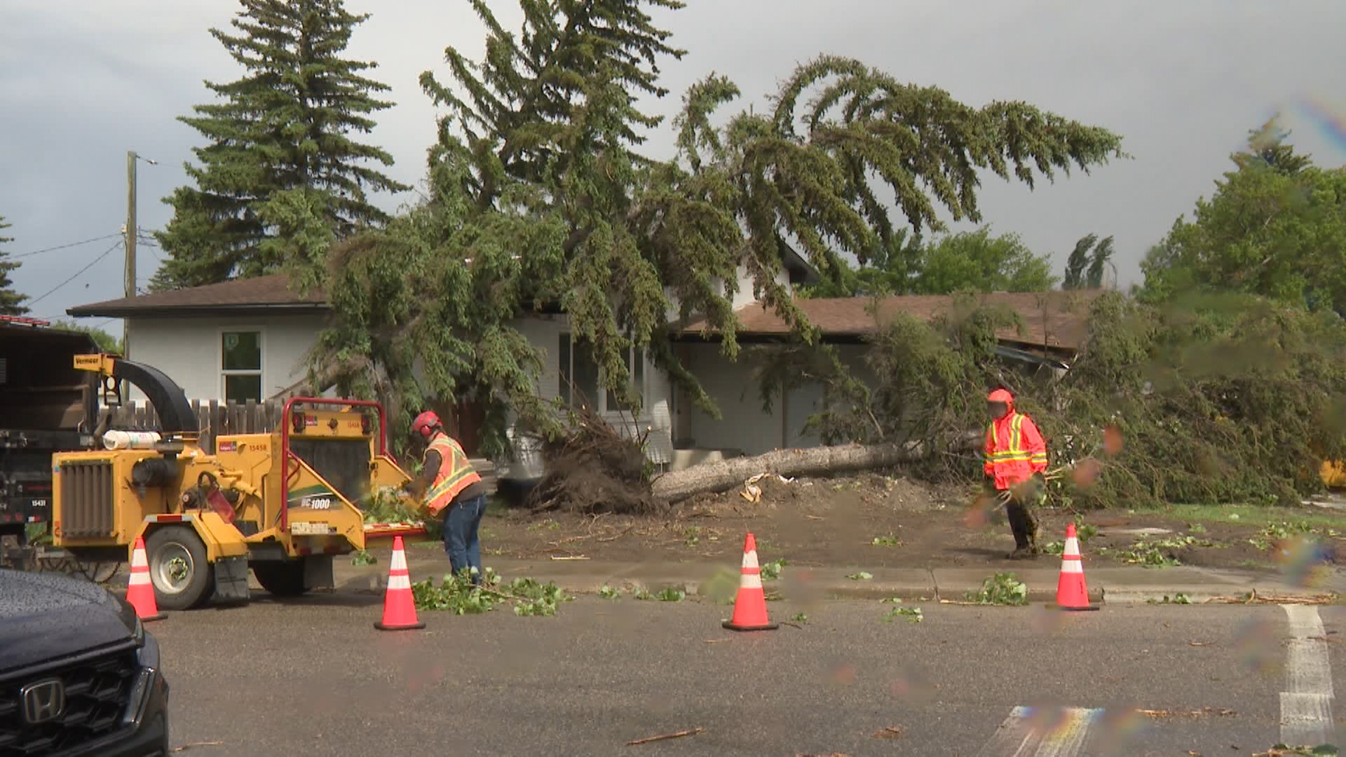
- Wind speeds: Straight-line winds clocked up to 60 kilometers per hour in Calgary, while the Lethbridge and Medicine Hat corridors faced destructive gusts hitting 80 kilometers per hour. That is fast enough to snap mature tree branches and flip high-profile vehicles on Highway 3 or the Trans-Canada.
- Hail threats: Areas slightly west of Medicine Hat, like Strathmore and Wheatland County, got hammered with quarter-sized hail by midday.
- The Tornado Variable: Northwestern Alberta just had a landspout tornado tear through Girouxville on Monday night without any formal tornado watch beforehand. The atmosphere across the province is primed for sudden supercell development, which is why the southern watch transformed so rapidly into a red-level emergency near Medicine Hat.
Why Southern Alberta Storms Are Unique
Alberta's geography makes it a literal breeding ground for violent summer weather. You have cool, dry air rolling off the Rocky Mountains crashing straight into warm, humid air pushing up from the United States or lingering across the prairies.
When those two air masses collide over places like Lethbridge or the Cypress Hills, the air doesn't just mix. It gets forced upward violently.
The storm that triggered the tornado warning near Suffield and Tilley was a supercell. Unlike a standard popcorn thunderstorm that dumps rain and dies in thirty minutes, a supercell possesses a rotating updraft called a mesocyclone. This rotation allows the storm to sustain itself, grow bigger, feed on its own energy, and produce tornadoes.
The Northern Tornadoes Project has already tracked multiple landspouts in the province this season. But the system moving through southeastern Alberta carried genuine supercell capabilities, making it a threat to life and property rather than just a dramatic photo opportunity for storm chasers.
What to Do Right Now
If you are currently inside the watch or warning zones in Calgary, Lethbridge, Medicine Hat, or any surrounding rural counties, stop waiting for the sky to turn green before you act.
Move your vehicle inside a garage or under cover if you can. Hail damage claims in Alberta break insurance records almost every single year, and quarter-sized ice chunks will obliterate your windshield. Securing loose patio furniture, trampolines, and garbage bins right now prevents them from becoming dangerous projectiles when those 80 kilometer per hour winds arrive.
For those in the immediate path of the southeastern cells near Medicine Hat and Redcliff, head indoors immediately. Basements are your best bet. If you don't have one, find an interior room like a bathroom or closet on the lowest floor and put as many walls between yourself and the outside as possible. Stay away from windows.
This system is moving fast, tracking southeast toward the Saskatchewan border. Do not get caught driving into it on the highway, as visibility can drop to zero in seconds during these localized downpours.
Get inside, keep your devices charged, and keep an eye on local radar updates. The worst of the atmospheric energy will taper off into the late evening, but until then, treat the alerts with the seriousness they deserve.


